Development Methods used for the RCS
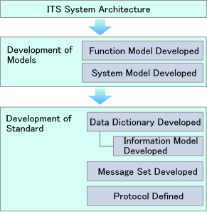
The development of RCS was based on Japanese System Architecture.
・The function allocation models corresponding to 20 individual systems expected to be deployed by the road administrator were built based on Japanese ITS System Architecture.
・Based on the function allocation model, a system model was built.
・Based on the two models above, we developed standards for data dictionaries, message sets, and protocols.
| Target systems | ||
| 1 | Advance Traffic Information system | This system allows access to information regarding traffic and reservations for roadside facilities from home, the office, SA and PA, and "Michi-no-Eki" |
| 2 | Parking Information system | This system allows access to information regarding parking situations at any given destination or facility and provides possible combinations of transport modes that may be taken. |
| 3 | Public Transportation Information system | This system provides information on public transportation matters such as transfers, and allows users to make reservations, purchase tickets, reserve facilities and pay for their use in advance. |
| 4 | Highway Bus Information system | This system provides information on traffic conditions, accidents and emergencies as they pertain to the specific location of a highway bus at any given point in time. |
| 5 | External Information Exchange system | This system gives users access while in transit, to information on travel, public transportation, and roadside facilities, and enables advance payment for facility use when necessary. |
| 6 | Specially Permitted Vehicle Administration system | This system allows specialized vehicle applications to be submitted electronically, and provides information on road use permission, reduced speed zones and other required terms of road use. This system will also collect driving records as reference data for permit application reviews. |
| 7 | Oversized Load Surveillance system | This system automatically calculates the size of a vehicle load and collects results as reference data for review of permit applications. |
| 8 | Road Management Support system | This system collects road traffic information as rudimentary data for road construction and maintenance plans. In addition, it allows bridges and tunnels to be remotely monitored and enables the expedient detection of any abnormalities. |
| 9 | Road Environment Information system | This system collects information on road environments; information serves as material for maintenance of road environments. |
| 10 | Disaster Monitoring system | This system collects information on disasters and unusual weather conditions and utilizes it to restrict and restore road use. In addition, this system provides vehicles expected to pass through the area in question with information on the condition of roads affected by disasters and unusual weather conditions. |
| 11 | AHS system for Cold Districts | provides access to the information on a vehicles, pedestrians, obstacles in a blind spot of ahead and behind the driver and weather conditions as well as geographical road alliance and real-time surface conditions |
| 12 | Detection system for Unforeseen Occurrences | provides information on a vehicles, pedestrians, obstacles in a blind spot and alerts to the presence of an oncoming vehicle |
| 13 | EDI Support system for Commercial Vehicles | gathers information on commercial vehicles and freight and provides related road traffic information to commercial carriers |
| 14 | Traffic Information system | provides information en route on road traffic and facility etc on demand and allows a user to make reservation if required |
| 15 | Routing system | provides access on demand to optimal routes based on the current traffic information and predictions |
| 16 | Traffic Management system | gathers road traffic related information and provides it on demand to the road traffic clearing houses |
| 17 | Traffic Management system for Specific Occurrences | provides road traffic and restriction information on demand to road traffic clearing houses when disasters or unusual weather conditions occurs |
| 18 | Automatic Toll Collection system | senses vehicle information and the number of passengers automatically and allows a user to electronically pay fares for parking, ferry and car-train |
| 19 | Public Transportation Operation Support system | gathers information on transit operations and the number of potential passengers at bus stops and relays it to the user when emergency of transit, provides needed information including the emergency site and most direct routes |
| 20 | Pedestrian Support system | gathers information on pedestrian's present location, destined facility and passing routes via a mobile terminal of the pedestrians en route allows the elderly to access information on elevator, wide sidewalk and etc, if needed |