3.Coastal environmental investigations by impact response flow
1) Introduction
The amendment of the Seacoast Law in 1999 added "development and conservation of coastal environments" to the purposes of the Seacoast Law. Nevertheless, there remain problems during the various phases of such works, such as the tradeoff among protection, usage and the environment, as well as the lack of technological knowledge for promoting coastal development in consideration of the natural environment. In addition, endemic natural life forms inhabit sand beaches, and the sand beaches themselves help to purify water quality. Thus, the environmental value of sand beaches has become recognized, and so it is important to understand the impact of coastal conservation facilities on ecosystems.
Recently, the concept of adaptive management in implementing coastal works has been presented, and it has become increasingly important to understand the relationship between coastal conservation facilities and the coastal environment and ecosystems in the surrounding areas when drawing up coastal conservation plans and implementing works. However, many factors in coastal ecosystems remain unknown, and there is a paucity of measurement data for elucidating them. So far, consideration of natural life forms when planning and implementing coastal works has often focused on valuable species and fishery resources species, and conservation of the ecosystem in coastal areas has hardly been considered.
Thus, methods for estimating and assessing variations in the coastal environment in line with coastal development based on adaptive management, as well as the impact of coastal conservation facilities constructed in sand beaches on ecosystems, were reviewed in this study. Based on these, investigations for implementing environmental management in sand beaches were examined.
2) Environmental variation due to installation of coastal conservation facilities
Changes in natural life forms due to physical changes of the environment caused by installing coastal conservation facilities are summarized in Table 1 showing the correlation between the waves and currents and the natural life forms, as well as in Table 2 showing the correlation between the topography and deposits and the natural life forms. As a result, it has been clarified that case examples, investigations, and researches are insufficient on the following points:
1) Correlation between the current force (e.g., flow velocity) and the distribution of natural life forms
2) Correlation between the quantities of deposits which become coarser and more fine-grained and the natural life forms
3) Correlation between the benthos except for specific natural life forms (e.g., little clams) and the water depth and seashore gradient
Table 1 Impact of wave and current variations on natural life forms
Table 2 Impact of topology and deposit variations on natural life forms
In addition, based on the existing literature, information on the food chain in sand beach ecosystems was tabulated in Table 3.
Table 3 Information on the food chain in the sand beach ecosystem
Tables 1 to 3 were compiled into an impact response flow chart ("I.R.F. chart") (Figure 1). This chart visually shows the exact places where a sand beach ecosystem is affected by structures based on the concept of food chain in sand beach ecosystems. The numbers in the chart correspond to those in Tables 1 to 3. As the arrows are concentrated on benthos in this chart, benthos are considered to be the most affected natural life forms in the sand beach ecosystem. In addition, the results of natural life form investigations conducted at seven coasts under the direct jurisdiction of the River Bureau, MLIT, were applied to this I.R.F. chart.
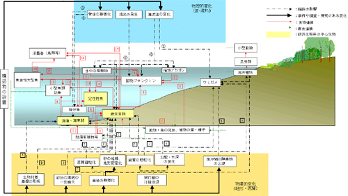
Figure 1 Impact response flow chart of sand beach ecosystem
3) Coastal environmental investigation using the I.R.F. chart
To implement a coastal environmental investigation using the I.R.F. chart, the investigation flow shown in Figure 2 was proposed.
(1) Understanding of biota
The state of natural life form inhabitation in the target coast needs to be grasped. Acquisition and sharing of environmental data obtained by the population census of seaside natural life forms and other surveys are expected.
(2) Creation of an I.R.F. chart
An I.R.F. chart was drawn up by gathering the impacts of the changes in waves, currents, topography, and deposits on natural life forms, as well as information on the food chain in the sand beach ecosystem, of the target coast, together with general knowledge concerning coasts.
(3) Extraction of species which affect the entire ecosystem (keystone species)
The I.R.F. chart shown in Figure 1 is prepared for the respective coasts incorporating (1) and (2) above, and the species of natural life forms (specific natural life forms depending on the circumstances) on which many arrows are concentrated are extracted from the I.R.F. chart of the target coast.
(4) Refining of the investigation items
The physical changes of the extracted species of natural life forms were narrowed down, which is the main issue to be clarified, because the correlation between the distribution of natural life forms and the topography (water depth, gradient, etc.) and deposit grain diameter in sand beach ecosystems has not yet been clarified. In addition, it is considered desirable for understanding the variation of ecosystems to investigate various aspects of the food chain. For instance, the stomach contents of resident fish need to be investigated for identifying the food chain relationship between benthos and resident fish.
(5) Implementation of investigations based on the investigation items
The frequency, periods, areas covered, and methods of investigations need to be established in consideration of the life history of the species of natural life forms.
(6) Variation assessment
It is important to evaluate the investigation results and use them for designing and conducting works in the future, as well as for further investigations.
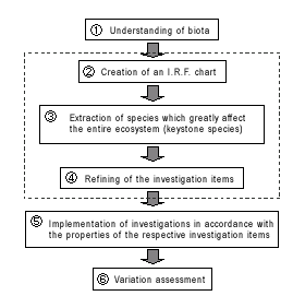
Figure 2 Flow of coastal environmental investigations
4) Conclusion
In this study, case examples and knowledge mainly in the field of coastal engineering were collected, and the results were visually and systematically compiled into the I.R.F. chart which incorporates the concept of the food chain for sand beaches which has received little attention to date. Furthermore, the environmental investigation flow was proposed based on this I.R.F. chart. It is expected that conservation of coastal ecosystems will be promoted by improving the acquisition of verification data at sand beaches and accumulating knowledge based on this investigation flow.
Reference:
Meguro et al. (2005), Proposal of Coastal Environmental Investigations Using the Impact Response Flow based on the Concept of Ecosystems, Civil Engineering in the Ocean, JSCE, pp. 235-240.