1. Comprehensive sediment management
Since the period of high economic growth in Japan, river gravel has been taken to meet the growing demand for construction aggregate, and numerous dams have been constructed for securing water resources and for controlling floods. In coastal zones, on the other hand, harbors and fishing ports with large-scale breakwaters have been developed. Consequently, the equilibrium of sediment balance in coastal zones was disrupted, and 160 ha of the national land per annum has been lost due to considerable coastal erosion.
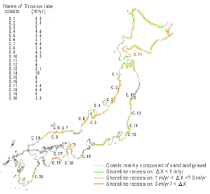
Figure 1 shows the amount of shoreline recession at gravel beaches from 1951 to 1991.
To counter the coastal erosion, revetments and levees were constructed, and wave absorbing dykes and detached breakwaters were installed; however, this actually worsened the coastal environment. Accordingly, full-scale comprehensive sediment management of the sediment transport system and coastal conservation that balances protection, the environment, and usage has been implemented.
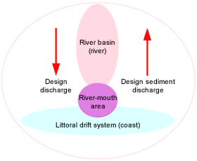
The sediment transport system comprises a basin where inland sediment transport takes place (river), the littoral drift system where nearshore sediment transport takes place (coast), and the river-mouth area which is at the interface of these two areas (
Figure 2). To draw up a comprehensive sediment management plan in the sediment transport system, 1) the amount of sediment discharge (the amount of littoral drift) in the littoral drift system needs to be determined as shown by arrows in Figure 2. At the same time, 2) the correlation between the sediment behavior in the river-mouth area and the amount of littoral drift due to ocean waves needs to be identified because not all of the sediment supplied from the river to the river-mouth area becomes littoral drift.
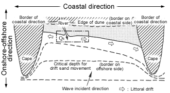
Of these, 1) requires further research, e.g., determination of the target littoral drift system (
Figure 3), understanding of the predominant direction and the amount of littoral drift, estimation of the process of coastal topography formation, and prediction of coastal topography deformation. Meanwhile, 2) also requires further research, e.g., understanding of the hydraulic phenomena at the river-mouth section during flood, understanding of the process of river-mouth terrace formation together with the process of river-mouth bar variation, understanding of sediment movement due to floods and waves, and understanding of the amount and the grain size of sediment which flows out from the river and affects the coast.
To work on these research themes, the Coast Division launched the "Investigations regarding Monitoring of the Amount of Sediment Transport in the Littoral Drift System" (fiscal 2003-2005 research theme designated by the National Land Technologies Workshop, Ministry of Land, Infrastructure and Transport) in collaboration with the respective regional development bureaus, under which it is examining methods for estimating littoral drift, which is the required amount of design sediment transport in the littoral drift system, as well as investigating sediment behavior during weather disturbance (floods and tidal waves) and at ordinary times.
 | Figure 1
Map of actual state of nation-wide coastal erosion
(2001 edition) |
 | Figure 2
Conceptual drawing of the sediment transport system |
 | Figure 3
Conceptual drawing of the littoral drift system |
Concept of the littoral drift system
* Section with continuous littoral drift in the coastal direction
* Section from the edge of the dune to the critical depth for the drift sand movement in the onshore-offshore direction
* Area where the rock species and mineral composition of the distributed sediment are similar
|
